Sunday, June 24, 2012

SJS50 1st place FINISH!

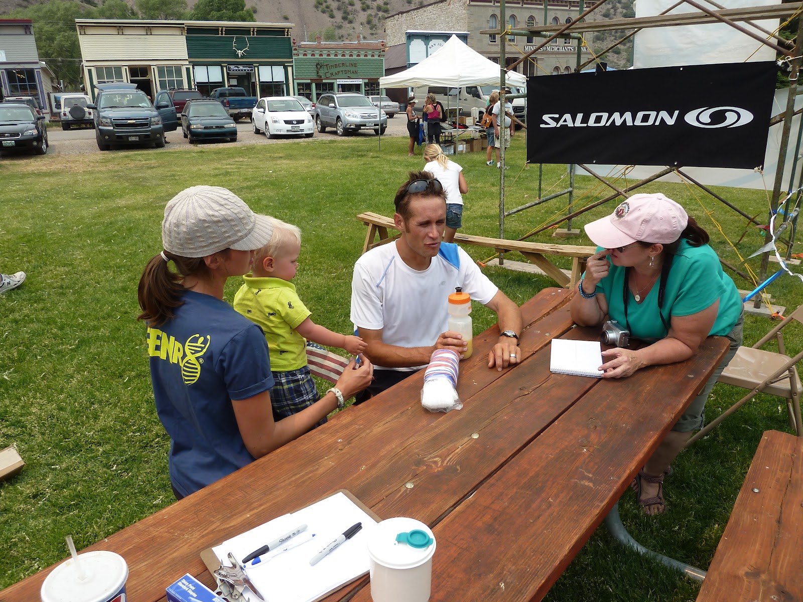
Join me in congratulating Jason in his 2nd FIRST PLCE finish in an ultra marathon in 1 month. My name is 'Bird-Dog' aka; 'Gator-Aid'! Jason agreed to let me co-author this blog post with him because he is still soaking his legs in the Lake Fork of the Gunnison River.


     Jason finished "The San Juan Solstice 50 Mile Run" in 8 hours 13 minutes. This is the all time 2nd best time for this amazing run and is also held by Dakota Jones. Hosted out of Lake City, CO. at an elevation of 8,671, the race course takes the ultra-runners to climb almost 13,000 vertical feet.

     In this post we'll go over pre-race preparations, Jason's course strategy and his post race rituals. Ultra marathon running pushes the human body to its ultimate limit of stamina and endurance. Ultra marathon running at altitude on mountain wildwood trails is an entirely different animal! And, that's why jason takes extra measures to prepare himself for these massive challenges.

     Trail running can become confusing and loosing your direction is easy when fatigue and exhaustion set in. Jason showed me the race course on his topo map and he had already been to all of the intersections where the trail crossed automobile roads. Secondly Jason cross referenced the altitude changes and set goals for every aid station.


     When it comes to calorie intake Jason knows it's important to consume at least 200 calories per hour. His preferred method of transportation is 2 hand-held water bottles vs. belts or backpacks. Among his long distance trail running friends they find this is the fastest easiest way to transport their liquid and sports mix drinks. Jason's newest discovery in endurance racing technology is Vitargo. He says that this powder water mix is so far superior because of it's fast delivery engineering, without any chemical taste.  The other trend in endurance racing that is going well for Jason is his Hoka One's! 

These are not attractive looking shoes. . . In fact, Jason let me borrow a pair to wear around town and a 16 yr. old high school girl told me I looked like I was wearing 'Clown - Cruisers'! Ha!! ~ I had to laugh, but if you want my opinion, I'm not trying to impress anyone out on the trail and the comfort that Hoka One One provides helps me conserve energy on long runs. Jason completed his course running technical outfitting with polarized photo-chromatic sun glasses and Injinji socks which promote natural toe movement.

     After every run 12 miles or longer Jason makes it a point to soak his leg muscles in cold water for 12 minutes. He calls it the 12/12 rule and he thinks it can cut your recovery time in half. . Living on the road the most readily available cold water is any natural stream or creek. Although filling up the bath tub with cold water and ice is even more effective at cleansing sore muscles of lactic acid and reducing inflammation in connective tissue. Although, Jason stays away from alcoholic beverages in between races, his post race ritual always includes a frosty cold one! I saw Jason talking to a lot of the other runners, race officials and local media people.

The day after a race is the only day that Jason doesn't run at all. Swimming and hanging out with 'the fam" is what he's all about anyway and it was good to see him celebrate with relaxation. Jason tells me he will post a 'race-report' shortly, once he has some time to de-compress from the race.

Tuesday, June 19, 2012

Silverton Running and Preparation for the San Juan Solstice 50M

Como Lake
We have now been playing in Silverton for 2 weeks, with a short two day trip over to Lake City last week.
We have enjoyed this last two weeks the most.  The high alpine lakes, creeks, rivers, forests and awesome mountains towns of the San Juans are really what we love the most.
Some Snow 

I have done a handfull of GREAT runs in the last few weeks.  Brendan Trimboli came up from Durango and camped with us for a night and we did a great run from just a few miles up the road from our camp on Cement Creek.  We dropped over a pass down to where highway 550 runs and tried our best to find a non-road route to Red Mountain Pass where we were going cross back into the drainage we were camped and parked.  Unfortunately we got a little confused, couldn't find a good trail up to the pass and we made our way back via pipeline trail and up Corks Screw pass.
Going Up

After the run with Brendan, we hit Velocity Basin and the lake at the foot of the awesome chute "The Great One" at Silverton Ski Area.  The lake is at just over 11,000 feet, the water perfect for soaking and an impressive place, just miles up from our camp.
Velocity Basin with "The Great One" in view
Hanging out at Velocity Basin
Brendan attempting to kick his anemia...
Sunday after the run with Brendan, I did a nice run up Maggie's Gulch (great name!), to the continental divide and then on the Continental Divide Trail for some mileage at altitude.
Had to both run and drive this one!  The toilet wasn't that impressive though. 
Falls in Maggie's Gulch 
The Taco does it all
Another great run wasn't even on trails but instead on a jeep road.  I ran from Hwy 550 up Ophir pass, down to Ophir for 6 miles and back.  The start was at about 10,000 feet with the pass at 11,750 feet and Ophir at 10,000 feet for 3,500 feet of climbing.  The views from the pass down to Ophir were phenomenal and again I had to share this one with Maggie and Felix via our truck.  

The frequent Marmot

Looking down Ophir Pass

The road down to Ophir 
Ophir

My wonderful wife!
 We are really having a blast.  We went to the "Taste of Silverton" where we enjoyed some food, music, dancing and fun out on Blair Street in Silverton.  We have been hanging out with Dakota Jones along with some running.  I am in taper mode for my race this weekend in Lake City, the San Juan Solstice  50 Mile. I am really, really excited for this race.  First off, the loop race will be amazingly fun, beautiful, challenging (12,000+ feet of climbing) and I can't wait.   

Wednesday, June 13, 2012

The San Juan Mountains and Silverton

Felix's First Backpacking Trip

Yoga at Camp 
Add caption


We have been in the Durango and Silverton area now for 12 days.  Without a doubt, the San Juan mountains are my favorite place in the Colorado, if not, all of the US.   I love hanging out in the cool towns, running, biking, white water kayaking, backpacking, etc...

We stayed 6 nights on Cascade Creek about 25 miles out of Durango towards Silverton.  We landed a great camp spot by the creek with trail access just up the dirt road.  I did a number of great runs up to the amazing cascades and waterfalls.  Camp was at about 9,500ft and my running went up to 11,000ft everyday.

Half way through our stay we backpacked up the creek about 4 miles and stayed for two nights.  The views were epic, the creek was close and we were on the edge of a beautiful meadow.  Felix did well sleeping in the 3 man tent with us and we had some great hikes up to the falls.  One of the nights we had a good rain that soaked and froze us pretty good.  Overall, our first backpack camping trip was a success.

I did one run up to a pass at 12,500ft before heading to Silverton.   I ran up Cascade Creek to Engine Creek up to the Colorado Trail.  I ran across a bit of snow, but it was early and the snow was firm enough to run across.   I really enjoyed the great views on the Colorado Trail.
Kendall Mtn From Silverton

On Saturday I did a long run from Silverton.  Plans sort of fell through to join some people and I was in a position where I would make up and long run route.  I ran from Kendall Mountain ski area up along a jeep trail for a while climbing about 750 feet before the jeep road ended.  I tried to find another trail but ended up running back down to the ski area where I eventually found a single track trail.  45 minutes later I was cruising out of town and on the trail of Dakota Jones.  I saw Dakota earlier before I began my run and there was not doubt that the fresh Montrail track's were his.  The trail led to a steep jeep road.  Above the jeep road was a sort of mining bucket chair lift, for a lack of a better way to describe it, going to some mine along a creek.  As my run continued I had a number of turns where I had to make a decision on which way to go, at these crossroads, I would walk around each turn searching for Dakota’s foot prints.  Because of regular wet dirt or mud or dry dusty sand, I was able to figure out each turn.  The only problem with my investigative running route approach, was that it added about 5 minutes at every juncture.

The road climbed above tree line and then some pretty ponds that were followed by some decent sized snowfields on the road.  I did more investigating and some good guessing on best routes to make the 12,500ft pass.  The jeep road was now a trail and at the pass I had to make a tough decision, to randomly follow into a different valley and drainage where I had no idea where I was going, or to turn back… easy, down the new drainage.  I was comforted by Dakota’s tracks and made a very steep descent to some views of waterfalls and a road where some people were camped.  A quick creek crossing and I was asking the campers about a blond runner with a  hand water bottle.  Up the road to Highlands Marry Lake trail I went following Dakota’s ghost.  Up a few thousand feet along a muddy trail I went to the lakes.  I signed the wilderness check in sheet, just in case, and was comforted by an over simple map showing a trail off the lakes that lead to a road to Silverton.  Once up to the lakes I lost Dakota’s trail with 3 options for trails at a number of lakes.
Views from the Weminuche Wilderness around Mary lakes

 I spent nearly 45 minutes going two different wrong ways.  The body was getting tired with not much to eat and the stress of being alone and not knowing where to go at 12,000 feet was getting very heavy on the body and mind.  After getting back on Dakota’s trail I was further challenged with some off trail explorations to get over a ridge I was sure led to where I wanted to be.  Next up would be some serious snow and hail to make things extra fun.  On this side of Kendall Mountain on what I would later find out to be Whitehead Trail, there was a lot of snow still and sinking through, post hole style, was common.  At this point I was over 5 hours into a long run adventure and ready to be home.  Just before making the jeep road that wraps back to Silverton, I slipped running off a snowfield on a very slippery snow, slush, hail, water, and mud mixture surface.  I wacked my knee very hard bruising it for over a week and sustaining a few cuts.  My knee was swollen and tender every day when I ran.

Finally back to the car in under 6hrs with about 8,000feet of climbing and 28 miles all above 9,300 feet, I bought Maggie a Chai to try and make it up to her a little bit for being late back to the camp. 

Since my adventure long run in Silverton, we moved our base camp to Cement Creek.   Just a mile out of Silverton, we are enjoy biking in and out of town where we enjoy the funky little city of Silverton and all the wonderful mountains, rivers, passes and creeks of this magic valley. 

Next post, my first whitewater kayaking outing, running with Brendan Trimboli and a few great runs around Silverton. 
      

Friday, June 8, 2012

Grand Canyon Fun


After our stay in Flagstaff, we headed north for a short 70 mile drive to the Grand Canyon.  Immediately I realized my preconceptions of what the Grand Canyon was like was actually incorrect. I envisioned the rim of the canyon to be a treeless arid desert similar to Canyonlands National Park.  
Instead, we were pleasantly surprised with Ponderosa forests.  The Monday night we arrived we were also surprised to find that a national park annual pass is free to military (I am still technically active duty until mid July) and secondly that all the camping was full.  Luckily, there was free camping just a few miles outside the entrance and we avoided our first pay to camp situation. 
I did an hour of research that night on doing a run to the bottom of the canyon.  Pecking away on my phone and looking at the free map from the park that refuses to show trails details any further than a few miles down into the canyon (hiking to the Colorado river from the rim is absolutely not recommended.  

I managed to figure out that running down the South Kaibab trail then crossing the Colorado river via a bridge and then back on a different bridge (not sure why they have two bridges within a mile) and up Bright Angel trail would be the best run option.  This horseshoe shaped route is around 16 miles with around 4,800 feet of climbing (South Rim is 7,200ft and the river is at 2,400 feet). 
The Start

The end of May is reasonable time of year to run this route, but an early start is necessary.  I didn’t exactly get an early start, but it didn’t ruin the run either.  Maggie dropped me off at the road leading to the South Kaibab trail head, you have to take a shuttle to get the extra ¾ of a mile down the road, at about 9:15.  
Canyon Kitty

After taking a picture with a random house cat on the edge of the canyon rim I was off.  The trail down is wonderful.  The Grand Canyon was a unique run in many ways, one of which is that the trail is consistently either down or up, where mountain trail running most always has up and down on both the ascent and decent.  The trail was impressively built with great switchbacks, widths and consistent grade.  The views were, of course, outstanding and I was thankful for the relatively wide and smooth trail otherwise I might have fallen to my death gaping at the canyon. 


After numerous mule trains and a 4 or so miles, all the day hikers were gone leaving only a small splattering of permitted backpackers.  The canyon was relatively quiet and empty from miles 4 to 10. 
Down at the bottom of the canyon I could tell my legs had taken a beating in the hour straight of down hill running with zero breaks.  As I stared at the beautiful green water contrasting so well with the canyon walls, I decided since running rim to rim or rim to rim to rim was totally out of the question today, I would challenge myself by swimming across the Colorado river and back.  

Tell me the bridge doesn't look to be a huge upside down "V"... it isn't!
The bridge is FLAT

As I have kayaked/rafted the Colorado up stream in the Cataract Canyon (awesome 5 day trip!), West Water Canyon and Glenwood Canyon, I know the water is brutally cold, even when it is blazing hot in mid summer.  Stupid or not, I was determined to swim the Colorado.  I made my way safely up stream to avoid getting swept into the more rapid flowing water below the bridge, ignored the “no swimming” signs and stripped to just my running shorts.  Yeah, it was cold, half way across I experienced that numb, strange exhausted feeling that honestly scared me a bit.  I changed strokes, as I suck at swimming and pushed on.   On the other side of the river with no way to get back to the bridge due to the rock cliffs, I did aerobic exercise in the sun and nervously prepared to make my way back.  Needless to say, I made it across again, but it wasn’t exactly pleasant or easy. 
Refreshed and stupidly proud, I ran past the rafters and raft guides at the raft beach who were shaking their heads as they thought they were going to have to save me.  Down the canyon I went for the few miles until making my way up Bright Angel trail.  
Safe.... and cold despite how it looks.  

I was impressed by Bright Angel Canyon as it spans both sides of the Grand Canyon.  The creek running up the canyon is certainly a wonderful oasis for the hiker and runner making their way up in the hot sun. I found also that I was exhausted... from the swim.  Once a few miles up the trail the crowds were heavy, as drinking water and bathrooms are available numerous time up this route.  I filled my hand water bottle and enjoyed more Vitargo.  Vitargo goes down so well, I truly crave the stuff while I run, unlike other race fuel I’ve used in the past.  I had about 500 calories worth of Vitargo, which is two packets worth. 
Creek in Bright Angel Canyon

Passing all the hikers was both entertaining and at times frustrating.  Lots of tourists hike the canyon everyday with many of them foreigners, many of them totally lacking trail etiquette, and many of them are totally out of shape.   I also found in interesting that in general, Europeans had the most pleasant reaction to my running up the canyon.  One set of male and female middle aged Europeans gave me all sorts of complements and one guy said “respect... respect”.  Europeans sure do “respect” endurance athletics. 
DONE
Our Shower!
Future Star!

I made the top without walking, which was a temptation that last few miles, for a round trip in 2:39 minutes.  The following morning Maggie, intrigued by my experience, tackled the same loop, but hiked it.  I am so impressed she hiked this monster as 4,800ft vertical over 16 miles with temps at 100 degrees at the river is no joke.   
Maggie, the real star, after her 16 mile near 5K foot up and down romp in the heat!!

 We had a blast and I plan on doing a rim to rim to rim run in early October, want to join? 

Maggie's pic... check out her site for better stuff: www.maggieschlarb.com
Another Maggie Pic